From 5 to 7 May, StatEO26 was held at ESRIN in Frascati. This event brought together national statistical institutes, UN bodies, Earth observation experts and policymakers to address the question:
How do we make satellite data useful for official statistics?
Eurostat, the Food and Agriculture Organization (FAO), the Organisation for Economic Co-operation and Development (OECD) and statistical offices from across Europe filled the rooms, moving between plenary sessions on timeliness, accuracy, and the burden of reporting, and parallel thematic discussions where the work got specific. Forest was one of those themes.
Forests and the reporting gap no one can ignore
The forest session brought together a community with a lot of common ground. The reporting landscape is expanding – with REDD+, the EU Forest Monitoring Law, the Nature Restoration Regulation and the Global Biodiversity Framework – as is the demand for timely, consistent and policy-ready forest-related data. However, data on forest carbon stocks is currently limited for several reasons: national forest inventories were largely designed for other purposes beyond carbon estimation and ground measurements remain resource-intensive sometimes limiting the timeliness and accuracy of the information.
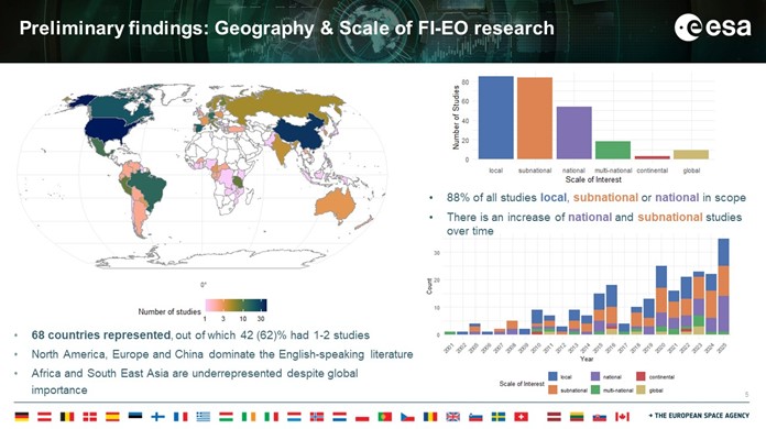
At the same time though, satellite-derived biomass products have matured considerably, and the research community is increasingly turning its attention to how they can support official reporting and statistics. Daniela Requena Suárez from GFZ – a WorldForest consortium partner – offered a useful vantage point on a systematic review of over 250 research studies, finding a clear directional shift: more and more work is being done on the integration of EO- and ground- data across the globe, with a dominance of local, subnational and national examples.
WorldForest is helping some countries measure their forests
It was in this context – of growing reporting obligations and incomplete ground data – that the ESA WorldForest project was introduced. Working closely with SERFOR – Peru as a key Early Adopter, WorldForest is stepping in to help the country overcome a major practical hurdle: the Peruvian National Forest Inventory is currently incomplete, with only about half of the planned ground plots currently collected in the Amazon region. Data scarcity is precisely where biomass maps and advanced satellite-supported modelling techniques present their greatest opportunity; bridging the gap left by limited ground data.
To demonstrate how the project is tackling this, Natalia Málaga from GFZ shared preliminary results from a WorldForest biomass estimation study in the Peruvian Amazonia. This work builds on a new “cookbook” for biomass estimation, designed to help countries choose the best methodological path for combining satellite information with ground measurements depending on the quantity and quality of the field data they have, and what their main needs are.
To test these methods where data is famously difficult to collect, Natalis’s team compared three different statistical approaches across four levels of geographic scale:
- The Peruvian Amazon as a whole.
- Specific forest zones (strata) within the Amazon.
- The regional state of Ucayali.
- Two local areas of interest: the Purús and Yavarí Indigenous Reserves, which due to their protection status are legally inaccessible to ground teams.
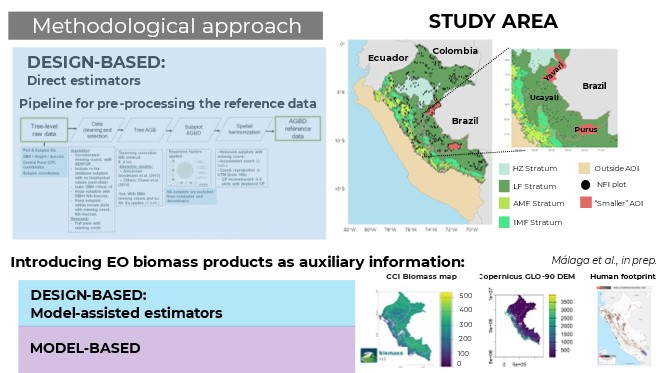
By analysing these distinct statistical approaches across varying geographic scales, the study aims to establish a reliable roadmap for integrating satellite data with limited ground measurements to accurately map forest biomass.
WorldForest is operationalising the science to transform national reporting
Christophe Sannier from GAF AG then returned to the broader operational mission of WorldForest, explaining how the project ensures that the underlying statistical methods of these models are robust. To achieve this, WorldForest consortium partner Norwegian University of Life Sciences (NMBU) – and more specifically Erik Næsset’s research group – is leveraging its extensive experience of calibrating earth observation data from airborne and spaceborne missions through statistically rigorous methods.
The team is using a clever workaround data limitation in Peru and Mozambique (both important end-users of the project): they are using a more complete forest dataset from six regions in Brazil. By studying how errors behave across Brazil’s dense network of forest plots, the scientists can simulate “missing data” scenarios in a controlled environment. This cross-border experiment provides WorldForest exactly what it needs: a clear blueprint and solid confidence to understand the potential systematic errors that modelling techniques can introduce. This is especially critical in areas where little or no data is available, and helps inform decision makers in Peru and Mozambique, about the associated risks.
Focus group insights can be implemented to build global standard practice
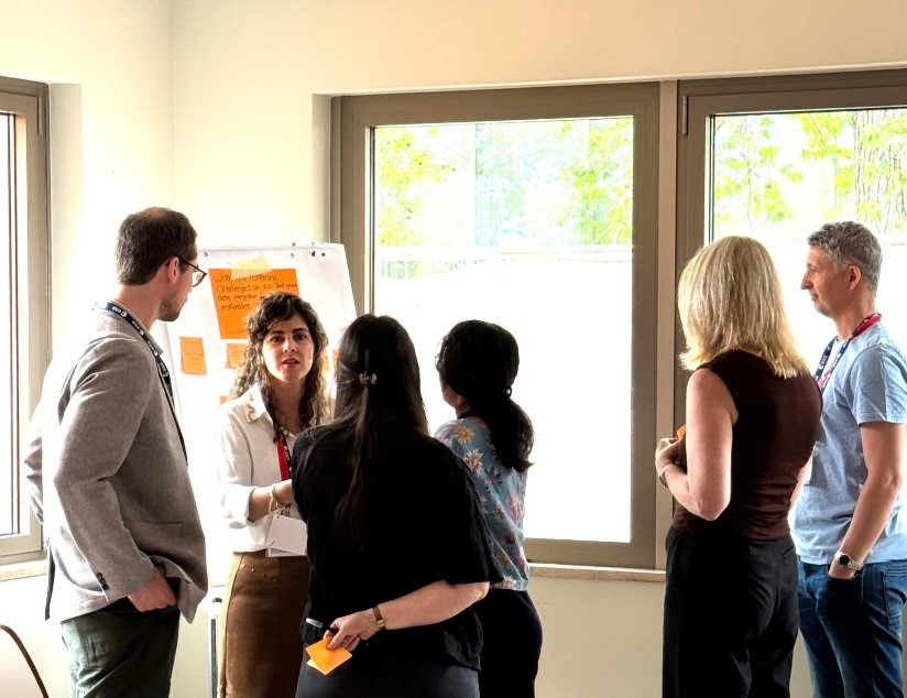
The last day of StatEO26 included a Forest Statistics workshop led by the Research and Development Component of the Global Forest Observation Initiative. This workshop had three intensive focus sessions that shifted the focus from specific case studies to community-wide action.
Rather than treating field campaigns and satellite mapping as distinct processes, the discussions established an ‘EO informs NFI’ concept, in which satellite data is utilised from the outset to optimise the design and scheduling of ground-based data collection in regions with limited data availability. The groups also addressed the practical issues of data harmonisation, noting that resolving plot-to-pixel discrepancies and GPS errors is essential for official reporting compliance. Crucially, there was a consensus for a strengthened link between ground-based and EO-based forest monitoring communities, as combining NFI data with satellite predictors has been shown to be more effective than using the data source alone, especially for small-area estimation within inaccessible territories.
Ultimately, these insights provided a pragmatic reality check: the primary barrier to progress is not the technology itself, but institutional silos and a lack of agreed-upon workflows. This is precisely the area in which the WorldForest project aims to make a difference.